Thank you for supporting this site ❤️
Make a donation
Make a donation
Gear up for your next adventure:
As an Amazon Associate, this site earns from qualifying purchases at no extra cost to you.
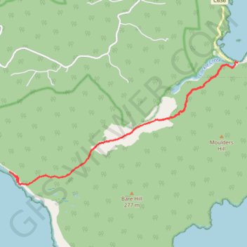
South Coast Track - Rocky Bay - South Cape Bay
Interactive trail map
Thank you for supporting this site ❤️
Make a donation
Make a donation
Gear up for your next adventure:
As an Amazon Associate, this site earns from qualifying purchases at no extra cost to you.
Trail profile
- Distance: 10.5 mi
- Elevation gain: 286 m
- Maximum elevation: 44 m
- Elevation loss: 289 m
- Minimum elevation: -1 m
- Moving time: 4 h 31 m
- Moving speed: 2.3 mph
- Maximum speed: 11.6 mph
- Total time: 5 h 25 m
- Global speed: 1.9 mph
Thank you for supporting this site ❤️
Make a donation
Make a donation
Gear up for your next adventure:
As an Amazon Associate, this site earns from qualifying purchases at no extra cost to you.
About this trail
Name: South Coast Track - Rocky Bay - South Cape Bay trail, distance, elevation, map, profile, GPS track
End: Cockle Creek, Recherche, Huon Valley, Tasmania, 7109, Australia (-43.58278 146.89410)
Coordinates: -43.61135 146.82031 -43.58263 146.89410
Thank you for supporting this site ❤️
Make a donation
Make a donation
Gear up for your next adventure:
As an Amazon Associate, this site earns from qualifying purchases at no extra cost to you.