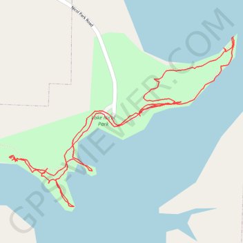
Lake Nicol park trails
- Distance: 1.8 mi
- Elevation gain: 42 m
- Maximum elevation: 101 m
- Elevation loss: 41 m
- Minimum elevation: 88 m
- Moving time: 59 m 37 s
- Moving speed: 1.8 mph
- Maximum speed: 4.1 mph
- Total time: 2 h 11 m
- Global speed: 0.8 mph
Interactive trail map
Trail profile
- Distance: 1.8 mi
- Elevation gain: 42 m
- Maximum elevation: 101 m
- Elevation loss: 41 m
- Minimum elevation: 88 m
- Moving time: 59 m 37 s
- Moving speed: 1.8 mph
- Maximum speed: 4.1 mph
- Total time: 2 h 11 m
- Global speed: 0.8 mph
About this trail
Name: Lake Nicol park trails trail, distance, elevation, map, profile, GPS track
Start: Nicol Park Road, Tuscaloosa, Tuscaloosa County, Alabama, 35406, United States (33.30878 -87.47643)
End: Nicol Park Road, Tuscaloosa, Tuscaloosa County, Alabama, 35406, United States (33.30887 -87.47640)
Coordinates: 33.30647 -87.48045 33.31082 -87.47356