Ice Box Canyon
Hike to the Ice Box Canyon in the Rainbow Mountain Wilderness. #Hiking #Canyon #Mountain #Nature #Wilderness
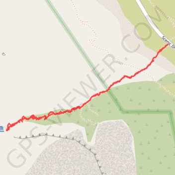
- Distance: 2.7 mi
- Elevation gain: 271 m
- Maximum elevation: 1,477 m
- Elevation loss: 271 m
- Minimum elevation: 1,297 m
- Moving time: 1 h 41 m
- Moving speed: 1.6 mph
- Maximum speed: 6.8 mph
- Total time: 2 h 46 m
- Global speed: 1.0 mph
Interactive trail map
Trail profile
- Distance: 2.7 mi
- Elevation gain: 271 m
- Maximum elevation: 1,477 m
- Elevation loss: 271 m
- Minimum elevation: 1,297 m
- Moving time: 1 h 41 m
- Moving speed: 1.6 mph
- Maximum speed: 6.8 mph
- Total time: 2 h 46 m
- Global speed: 1.0 mph
About this trail
Name: Ice Box Canyon trail, distance, elevation, map, profile, GPS track
Start: Ice Box Canyon, Ice Box Canyon Trail, Clark County, Nevada, United States (36.15002 -115.48408)
End: Ice Box Canyon, Scenic Drive, Clark County, Nevada, United States (36.15005 -115.48404)
Coordinates: 36.14334 -115.49954 36.15005 -115.48404