Thank you for supporting this site ❤️
Make a donation
Make a donation
Gear up for your next adventure:
As an Amazon Associate, this site earns from qualifying purchases at no extra cost to you.
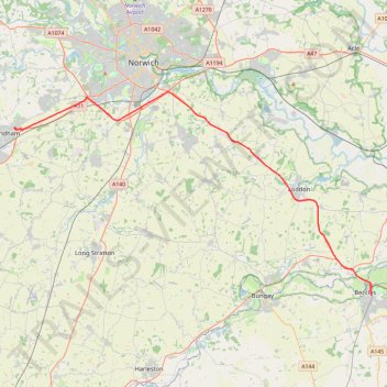
2026-04-25_12-01_Sat
- Distance: 25.9 mi
- Elevation gain: 326 m
- Maximum elevation: 52 m
- Elevation loss: 281 m
- Minimum elevation: 1 m
Interactive trail map
Thank you for supporting this site ❤️
Make a donation
Make a donation
Gear up for your next adventure:
As an Amazon Associate, this site earns from qualifying purchases at no extra cost to you.
Trail profile
- Distance: 25.9 mi
- Elevation gain: 326 m
- Maximum elevation: 52 m
- Elevation loss: 281 m
- Minimum elevation: 1 m
Thank you for supporting this site ❤️
Make a donation
Make a donation
Gear up for your next adventure:
As an Amazon Associate, this site earns from qualifying purchases at no extra cost to you.
About this trail
Name: 2026-04-25_12-01_Sat trail, distance, elevation, map, profile, GPS track
Coordinates: 52.45616 1.13539 52.60662 1.57104
Topography: East Suffolk topographic map, elevation, terrain
Thank you for supporting this site ❤️
Make a donation
Make a donation
Gear up for your next adventure:
As an Amazon Associate, this site earns from qualifying purchases at no extra cost to you.
Other hiking, mountain biking, running and outdoor activity trails
Click on a trail to view its statistics, map and profile.
2026-04-25_06-04_Sat
United Kingdom > England > Norfolk > Breckland District > Old Buckenham
Distance: 33.6 mi • Elevation gain: 233 m • Maximum elevation: 57 m