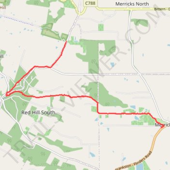
Red Hill to Merricks rail trail walk
- Distance: 6.1 mi
- Elevation gain: 117 m
- Maximum elevation: 213 m
- Elevation loss: 226 m
- Minimum elevation: 43 m
- Moving time: 1 h 34 m
- Moving speed: 3.8 mph
- Maximum speed: 12.0 mph
- Total time: 1 h 34 m
- Global speed: 3.8 mph
Interactive trail map
Trail profile
- Distance: 6.1 mi
- Elevation gain: 117 m
- Maximum elevation: 213 m
- Elevation loss: 226 m
- Minimum elevation: 43 m
- Moving time: 1 h 34 m
- Moving speed: 3.8 mph
- Maximum speed: 12.0 mph
- Total time: 1 h 34 m
- Global speed: 3.8 mph
About this trail
Name: Red Hill to Merricks rail trail walk trail, distance, elevation, map, profile, GPS track
Coordinates: -38.39097 145.02548 -38.36392 145.08826
Other hiking, mountain biking, running and outdoor activity trails
Click on a trail to view its statistics, map and profile.
Merricks to Red Hill rail trail walk
Australia > Victoria > Melbourne > Merricks
Distance: 6.3 mi • Elevation gain: 235 m • Maximum elevation: 214 m