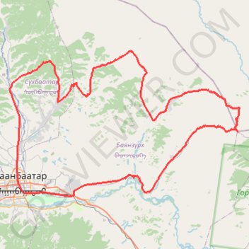
UDA 7 davaa challenge
- Distance: 84.0 mi
- Elevation gain: 2,583 m
- Maximum elevation: 2,015 m
- Elevation loss: 2,582 m
- Minimum elevation: 1,289 m
Interactive trail map
Trail profile
- Distance: 84.0 mi
- Elevation gain: 2,583 m
- Maximum elevation: 2,015 m
- Elevation loss: 2,582 m
- Minimum elevation: 1,289 m
About this trail
Name: UDA 7 davaa challenge trail, distance, elevation, map, profile, GPS track
Start: Great Mongolian Empire Street, Bayanzürkh, Ulaanbaatar, 17010, Mongolia (47.90511 106.92811)
End: Хүннүгийн гудамж, Bayanzürkh, Ulaanbaatar, 13312, Mongolia (47.90444 106.93060)
Coordinates: 47.89846 106.90011 48.10148 107.37750
Other hiking, mountain biking, running and outdoor activity trails
Click on a trail to view its statistics, map and profile.
A century solo ride - clockwise cycling the Bogd mountain #PowerMap #StatMaps
Distance: 65.8 mi • Elevation gain: 1,046 m • Maximum elevation: 1,671 m
A century solo ride - clockwise cycling the Bogd mountain #PowerMap #StatMaps
Distance: 65.8 mi • Elevation gain: 1,046 m • Maximum elevation: 1,671 m
Зуслан чэллэнж
Distance: 49.2 mi • Elevation gain: 1,330 m • Maximum elevation: 1,634 m