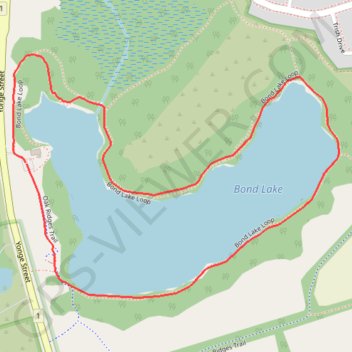
Import a GPX file

Bond Lake Loop

Oak Ridges Corridor Conservation Reserve. #Hiking #Running #Loop #OakRidgesCorridor

  • Distance: 1.7 mi
  • Elevation gain: 31 m
  • Maximum elevation: 313 m
  • Elevation loss: 31 m
  • Minimum elevation: 301 m

Interactive trail map

Trail profile

  • Distance: 1.7 mi
  • Elevation gain: 31 m
  • Maximum elevation: 313 m
  • Elevation loss: 31 m
  • Minimum elevation: 301 m

About this trail

Other hiking, mountain biking, running and outdoor activity trails

Click on a trail to view its statistics, map and profile.

Québec - Montréal - Saint-Laurent River - Lake Ontario - Niagara Falls

Canada > Quebec > Urban agglomeration of Québec > Quebec

#Bike #Ontario

Distance: 670.1 mi • Elevation gain: 4,804 m • Maximum elevation: 209 m

Toronto - Bradford

Canada > Ontario > Old Toronto

#Bike #Toronto #Bradford

Distance: 43.4 mi • Elevation gain: 577 m • Maximum elevation: 305 m

Gear up for your next adventure:

🧢Waterproof Hiking Hats - Keep the rain off your face while studying topographic maps
❄️Walking Crampons - Added traction for icy slopes and winter peak bagging
🔋Solar Power Banks - Keep your GPS and phone charged during multi-day expeditions
Lightweight Tents - Compact tents for backpacking and trekking
🧰Survival Kits - Emergency tools for remote environments

As an Amazon Associate, this site earns from qualifying purchases at no extra cost to you.