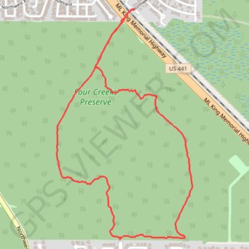
Four Creek Preserve loop
- Distance: 3.3 mi
- Elevation gain: 7 m
- Maximum elevation: 61 m
- Elevation loss: 6 m
- Minimum elevation: 57 m
- Moving time: 1 h 10 m
- Moving speed: 2.8 mph
- Maximum speed: 6.4 mph
- Total time: 1 h 10 m
- Global speed: 2.8 mph
Interactive trail map
Trail profile
- Distance: 3.3 mi
- Elevation gain: 7 m
- Maximum elevation: 61 m
- Elevation loss: 6 m
- Minimum elevation: 57 m
- Moving time: 1 h 10 m
- Moving speed: 2.8 mph
- Maximum speed: 6.4 mph
- Total time: 1 h 10 m
- Global speed: 2.8 mph
About this trail
Name: Four Creek Preserve loop trail, distance, elevation, map, profile, GPS track
Start: Yellow Trail, Gainesville, Alachua County, Florida, 32653, United States (29.71789 -82.37851)
End: Blue Trail, Gainesville, Alachua County, Florida, 32653, United States (29.71800 -82.37844)
Coordinates: 29.71789 -82.38334 29.73324 -82.37294