Import a GPX file

Hollow Glen

Gatineau Park. #Hiking #Snowshoeing #Loop #Gatineau
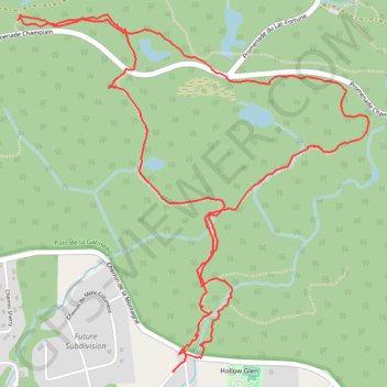
  • Distance: 4.8 mi
  • Elevation gain: 270 m
  • Maximum elevation: 345 m
  • Elevation loss: 277 m
  • Minimum elevation: 106 m

Interactive trail map

Trail profile

  • Distance: 4.8 mi
  • Elevation gain: 270 m
  • Maximum elevation: 345 m
  • Elevation loss: 277 m
  • Minimum elevation: 106 m

About this trail

Other hiking, mountain biking, running and outdoor activity trails

Click on a trail to view its statistics, map and profile.

Québec - Montréal - Saint-Laurent River - Lake Ontario - Niagara Falls

Canada > Quebec > Urban agglomeration of Québec > Quebec

#Bike #Ontario

Distance: 670.1 mi • Elevation gain: 4,804 m • Maximum elevation: 209 m

Renfrew - Ottawa

Canada > Ontario > Renfrew County > Horton

Ottawa River. #Bike #Renfrew #Ottawa

Distance: 61.1 mi • Elevation gain: 459 m • Maximum elevation: 168 m

Gear up for your next adventure:

📱Phone Mounts for Hiking - Secure mounts to carry your phone on trails
🔦Head Torches - Hands-free lighting for hiking and camping
📕Outdoor Navigation Books - Learn traditional and modern navigation techniques
🧭Professional Hiking Compasses - High-precision liquid-filled compasses for map reading and orientation
🥄Titanium Camping Sporks - The ultimate lightweight utensil for trail meals

As an Amazon Associate, this site earns from qualifying purchases at no extra cost to you.