Thank you for supporting this site ❤️
Make a donation
Make a donation
Gear up for your next adventure:
As an Amazon Associate, this site earns from qualifying purchases at no extra cost to you.
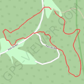
Huckleberry Trail - Twin Falls Resort State Park
- Distance: 1.4 mi
- Elevation gain: 61 m
- Maximum elevation: 706 m
- Elevation loss: 61 m
- Minimum elevation: 667 m
- Moving time: 37 m 41 s
- Moving speed: 2.2 mph
- Maximum speed: 3.9 mph
- Total time: 37 m 41 s
- Global speed: 2.2 mph
Interactive trail map
Thank you for supporting this site ❤️
Make a donation
Make a donation
Gear up for your next adventure:
As an Amazon Associate, this site earns from qualifying purchases at no extra cost to you.
Trail profile
- Distance: 1.4 mi
- Elevation gain: 61 m
- Maximum elevation: 706 m
- Elevation loss: 61 m
- Minimum elevation: 667 m
- Moving time: 37 m 41 s
- Moving speed: 2.2 mph
- Maximum speed: 3.9 mph
- Total time: 37 m 41 s
- Global speed: 2.2 mph
Thank you for supporting this site ❤️
Make a donation
Make a donation
Gear up for your next adventure:
As an Amazon Associate, this site earns from qualifying purchases at no extra cost to you.
About this trail
Name: Huckleberry Trail - Twin Falls Resort State Park trail, distance, elevation, map, profile, GPS track
Start: Huckleberry Trail, Wyoming County, West Virginia, 25876, United States (37.61700 -81.42406)
End: Huckleberry Trail, Wyoming County, West Virginia, 25876, United States (37.61711 -81.42434)
Coordinates: 37.61221 -81.42877 37.61726 -81.42164
Thank you for supporting this site ❤️
Make a donation
Make a donation
Gear up for your next adventure:
As an Amazon Associate, this site earns from qualifying purchases at no extra cost to you.