Johnston Canyon - Ink Pots
Banff National Park. #Hiking #Snowshoeing #Banff
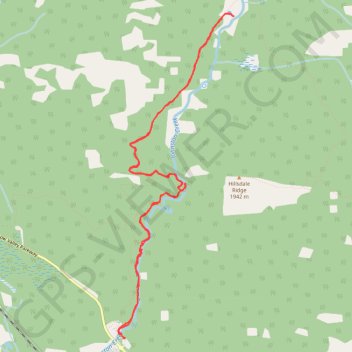
- Distance: 7.3 mi
- Elevation gain: 498 m
- Maximum elevation: 1,742 m
- Elevation loss: 498 m
- Minimum elevation: 1,435 m
Interactive trail map
Trail profile
- Distance: 7.3 mi
- Elevation gain: 498 m
- Maximum elevation: 1,742 m
- Elevation loss: 498 m
- Minimum elevation: 1,435 m
About this trail
Name: Johnston Canyon - Ink Pots trail, distance, elevation, map, profile, GPS track
Start: Bow Valley Parkway, Improvement District No. 9, Alberta, Canada (51.24589 -115.84007)
End: Bow Valley Parkway, Improvement District No. 9, Alberta, Canada (51.24589 -115.84007)
Coordinates: 51.24589 -115.84109 51.27839 -115.82260
Other hiking, mountain biking, running and outdoor activity trails
Click on a trail to view its statistics, map and profile.
Johnston Canyon - Upper Falls
Canada > Alberta > Improvement District No. 9
Johnston Creek. #Hiking #Snowshoeing #River #Falls #Forest
Distance: 3.1 mi • Elevation gain: 213 m • Maximum elevation: 1,559 m