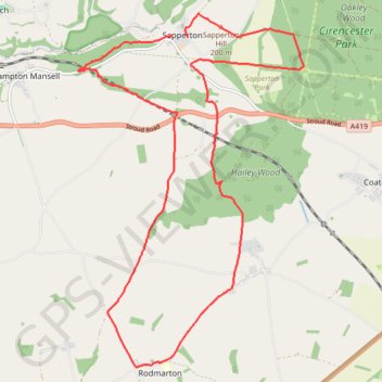
Sapperton to Rodmarton
- Distance: 12.0 mi
- Elevation gain: 264 m
- Maximum elevation: 201 m
- Elevation loss: 249 m
- Minimum elevation: 138 m
- Moving time: 4 h 2 m
- Moving speed: 3.0 mph
- Maximum speed: 5.0 mph
- Total time: 4 h 53 m
- Global speed: 2.5 mph
Interactive trail map
Trail profile
- Distance: 12.0 mi
- Elevation gain: 264 m
- Maximum elevation: 201 m
- Elevation loss: 249 m
- Minimum elevation: 138 m
- Moving time: 4 h 2 m
- Moving speed: 3.0 mph
- Maximum speed: 5.0 mph
- Total time: 4 h 53 m
- Global speed: 2.5 mph
About this trail
Name: Sapperton to Rodmarton trail, distance, elevation, map, profile, GPS track
Coordinates: 51.68035 -2.10157 51.73079 -2.04945
Topography: Cotswold District topographic map, elevation, terrain
Other hiking, mountain biking, running and outdoor activity trails
Click on a trail to view its statistics, map and profile.
Thames Head Loop Hike
United Kingdom > England > Gloucestershire > Cotswold District > Cirencester > Chesterton
Distance: 12.5 mi • Elevation gain: 150 m • Maximum elevation: 165 m
Dean2023-311
United Kingdom > England > Oxfordshire > Oxford
Distance: 192.8 mi • Elevation gain: 3,366 m • Maximum elevation: 290 m