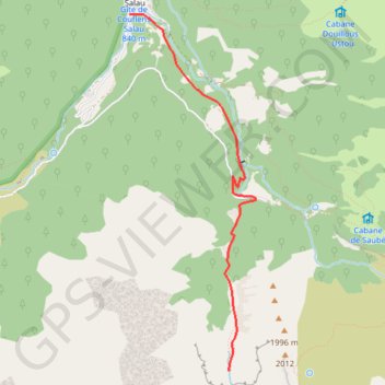
Le cirque d'Anglade
- Distance: 5.3 mi
- Elevation gain: 715 m
- Maximum elevation: 1,586 m
- Elevation loss: 715 m
- Minimum elevation: 871 m
Interactive trail map
Trail profile
- Distance: 5.3 mi
- Elevation gain: 715 m
- Maximum elevation: 1,586 m
- Elevation loss: 715 m
- Minimum elevation: 871 m
About this trail
Name: Le cirque d'Anglade trail, distance, elevation, map, profile, GPS track
Coordinates: 42.72792 1.18785 42.75557 1.20120
Other hiking, mountain biking, running and outdoor activity trails
Click on a trail to view its statistics, map and profile.
GR 10 - Traversée des Pyrénées
France > Occitania > Pyrénées-Orientales > Banyuls-sur-Mer
Distance: 543.6 mi • Elevation gain: 57,000 m • Maximum elevation: 2,599 m
Southern section — European Divide Trail
France > Auvergne-Rhône-Alpes > Drôme > Valence
Distance: 1,506.1 mi • Elevation gain: 42,375 m • Maximum elevation: 2,005 m
1 LUCENA - MONTPELLIER
Distance: 1,842.0 mi • Elevation gain: 29,500 m • Maximum elevation: 1,048 m