Make a donation
Gear up for your next adventure:
As an Amazon Associate, this site earns from qualifying purchases at no extra cost to you.
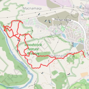
The Nguurung Bila Loop, the Woodland Loop, and the River Decent Tracks within The Corridor at Strathnairn walked
- Distance: 7.5 mi
- Elevation gain: 393 m
- Maximum elevation: 591 m
- Elevation loss: 385 m
- Minimum elevation: 432 m
- Moving time: 2 h 35 m
- Moving speed: 2.9 mph
- Maximum speed: 5.3 mph
- Total time: 2 h 53 m
- Global speed: 2.6 mph
Interactive trail map
Make a donation
Gear up for your next adventure:
As an Amazon Associate, this site earns from qualifying purchases at no extra cost to you.
Trail profile
- Distance: 7.5 mi
- Elevation gain: 393 m
- Maximum elevation: 591 m
- Elevation loss: 385 m
- Minimum elevation: 432 m
- Moving time: 2 h 35 m
- Moving speed: 2.9 mph
- Maximum speed: 5.3 mph
- Total time: 2 h 53 m
- Global speed: 2.6 mph
Make a donation
Gear up for your next adventure:
As an Amazon Associate, this site earns from qualifying purchases at no extra cost to you.
About this trail
Name: The Nguurung Bila Loop, the Woodland Loop, and the River Decent Tracks within The Corridor at Strathnairn walked trail, distance, elevation, map, profile, GPS track
Coordinates: -35.23612 148.96617 -35.22223 148.99543
Make a donation
Gear up for your next adventure:
As an Amazon Associate, this site earns from qualifying purchases at no extra cost to you.
Other hiking, mountain biking, running and outdoor activity trails
Click on a trail to view its statistics, map and profile.
Shepherds Lookout Loop within The Corridor at Strathnairn
Australia > District of Belconnen
Distance: 6.3 mi • Elevation gain: 329 m • Maximum elevation: 599 m
Woodstock Nature Reserve
Australia > District of Belconnen
Distance: 4.6 mi • Elevation gain: 265 m • Maximum elevation: 588 m
Cloudride24.FINAL
Distance: 639.3 mi • Elevation gain: 21,282 m • Maximum elevation: 1,754 m