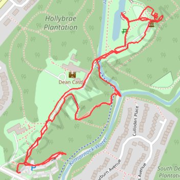
Dean Castle
- Distance: 1.3 mi
- Elevation gain: 34 m
- Maximum elevation: 66 m
- Elevation loss: 36 m
- Minimum elevation: 51 m
- Moving time: 38 m 4 s
- Moving speed: 2.1 mph
- Maximum speed: 4.3 mph
- Total time: 1 h 14 m
- Global speed: 1.1 mph
Interactive trail map
Trail profile
- Distance: 1.3 mi
- Elevation gain: 34 m
- Maximum elevation: 66 m
- Elevation loss: 36 m
- Minimum elevation: 51 m
- Moving time: 38 m 4 s
- Moving speed: 2.1 mph
- Maximum speed: 4.3 mph
- Total time: 1 h 14 m
- Global speed: 1.1 mph
About this trail
Name: Dean Castle trail, distance, elevation, map, profile, GPS track
Coordinates: 55.62070 -4.48639 55.62480 -4.48003
Topography: East Ayrshire topographic map, elevation, terrain
Other hiking, mountain biking, running and outdoor activity trails
Click on a trail to view its statistics, map and profile.
Irvine, Scotland to Stonehouse and back
United Kingdom > Scotland > North Ayrshire > Irvine
Stonehouse, South Lanarkshire, Bike, Loop
Distance: 69.5 mi • Elevation gain: 1,118 m • Maximum elevation: 302 m
Irvine, Scotland to Kilmarnock and back
United Kingdom > Scotland > North Ayrshire > Irvine
Afternoon Bike Ride
Distance: 21.2 mi • Elevation gain: 217 m • Maximum elevation: 91 m
Irvine, Scotland to Kilmarnock and back
United Kingdom > Scotland > North Ayrshire > Irvine
Evening Bike Ride
Distance: 26.1 mi • Elevation gain: 259 m • Maximum elevation: 92 m