Thank you for supporting this site ❤️
Make a donation
Make a donation
Gear up for your next adventure:
As an Amazon Associate, this site earns from qualifying purchases at no extra cost to you.
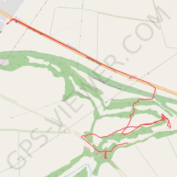
RE SK510750
- Distance: 2.0 mi
- Elevation gain: 20 m
- Maximum elevation: 126 m
- Elevation loss: 32 m
- Minimum elevation: 101 m
- Moving time: 56 m 44 s
- Moving speed: 2.1 mph
- Maximum speed: 46.4 mph
- Total time: 1 h 8 m
- Global speed: 1.7 mph
Interactive trail map
Thank you for supporting this site ❤️
Make a donation
Make a donation
Gear up for your next adventure:
As an Amazon Associate, this site earns from qualifying purchases at no extra cost to you.
Trail profile
- Distance: 2.0 mi
- Elevation gain: 20 m
- Maximum elevation: 126 m
- Elevation loss: 32 m
- Minimum elevation: 101 m
- Moving time: 56 m 44 s
- Moving speed: 2.1 mph
- Maximum speed: 46.4 mph
- Total time: 1 h 8 m
- Global speed: 1.7 mph
Thank you for supporting this site ❤️
Make a donation
Make a donation
Gear up for your next adventure:
As an Amazon Associate, this site earns from qualifying purchases at no extra cost to you.
About this trail
Name: RE SK510750 trail, distance, elevation, map, profile, GPS track
Coordinates: 53.26947 -1.24502 53.27634 -1.23151
Topography: Derbyshire topographic map, elevation, terrain
Thank you for supporting this site ❤️
Make a donation
Make a donation
Gear up for your next adventure:
As an Amazon Associate, this site earns from qualifying purchases at no extra cost to you.