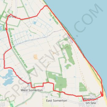
Horsey and Winterton Loop Walk
Northfolk Coast National Landscape
walking, horsey, winterton, winterton-on-sea, west-somerton
- Distance: 9.2 mi
- Elevation gain: 33 m
- Maximum elevation: 9 m
- Elevation loss: 33 m
- Minimum elevation: -3 m
- Moving time: 3 h 35 m
- Moving speed: 2.6 mph
- Maximum speed: 3.5 mph
- Total time: 4 h 42 m
- Global speed: 2.0 mph
Interactive trail map
Trail profile
- Distance: 9.2 mi
- Elevation gain: 33 m
- Maximum elevation: 9 m
- Elevation loss: 33 m
- Minimum elevation: -3 m
- Moving time: 3 h 35 m
- Moving speed: 2.6 mph
- Maximum speed: 3.5 mph
- Total time: 4 h 42 m
- Global speed: 2.0 mph
About this trail
Name: Horsey and Winterton Loop Walk trail, distance, elevation, map, profile, GPS track
Start: Somerton Road, Horsey, North Norfolk, Norfolk, England, NR29 4EF, United Kingdom (52.74268 1.63831)
Coordinates: 52.71518 1.63733 52.75104 1.69865
Topography: North Norfolk topographic map, elevation, terrain
Other hiking, mountain biking, running and outdoor activity trails
Click on a trail to view its statistics, map and profile.
Norfolk Coast Path - Horsey to Winterton-on-Sea Loop
United Kingdom > England > Norfolk > North Norfolk > Horsey
Distance: 13.2 mi • Elevation gain: 66 m • Maximum elevation: 17 m