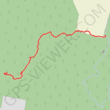
Long Beard Trail
- Distance: 0.6 mi
- Elevation gain: 44 m
- Maximum elevation: 468 m
- Elevation loss: 2 m
- Minimum elevation: 423 m
- Moving time: 10 m 38 s
- Moving speed: 3.4 mph
- Maximum speed: 6.6 mph
- Total time: 10 m 38 s
- Global speed: 3.4 mph
Interactive trail map
Trail profile
- Distance: 0.6 mi
- Elevation gain: 44 m
- Maximum elevation: 468 m
- Elevation loss: 2 m
- Minimum elevation: 423 m
- Moving time: 10 m 38 s
- Moving speed: 3.4 mph
- Maximum speed: 6.6 mph
- Total time: 10 m 38 s
- Global speed: 3.4 mph
About this trail
Name: Long Beard Trail trail, distance, elevation, map, profile, GPS track
End: Longbeard Trail, Oakland Township, Venango County, Pennsylvania, United States (41.50051 -79.76256)
Coordinates: 41.49822 -79.76955 41.50074 -79.76250
Other hiking, mountain biking, running and outdoor activity trails
Click on a trail to view its statistics, map and profile.
Longbeard Trail - Red Diamond
United States > Pennsylvania > Venango County > Oakland Township
Hiking, Biking, Horseback Riding
Distance: 1.1 mi • Elevation gain: 58 m • Maximum elevation: 468 m
Main Loop
United States > Pennsylvania > Venango County > Oakland Township
Hiking, Biking
Distance: 1.2 mi • Elevation gain: 19 m • Maximum elevation: 475 m
Long Beard Trail
United States > Pennsylvania > Venango County > Oakland Township
Distance: 0.8 mi • Elevation gain: 47 m • Maximum elevation: 465 m