Thank you for supporting this site ❤️
Make a donation
Make a donation
Gear up for your next adventure:
As an Amazon Associate, this site earns from qualifying purchases at no extra cost to you.
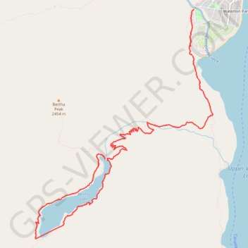
Bertha Falls - Bertha Lake
Waterton Lakes National Park. #Hiking #Loop #Bertha #WatertonLakes
- Distance: 6.4 mi
- Elevation gain: 211 m
- Maximum elevation: 1,800 m
- Elevation loss: 678 m
- Minimum elevation: 1,294 m
Interactive trail map
Thank you for supporting this site ❤️
Make a donation
Make a donation
Gear up for your next adventure:
As an Amazon Associate, this site earns from qualifying purchases at no extra cost to you.
Trail profile
- Distance: 6.4 mi
- Elevation gain: 211 m
- Maximum elevation: 1,800 m
- Elevation loss: 678 m
- Minimum elevation: 1,294 m
Thank you for supporting this site ❤️
Make a donation
Make a donation
Gear up for your next adventure:
As an Amazon Associate, this site earns from qualifying purchases at no extra cost to you.
About this trail
Name: Bertha Falls - Bertha Lake trail, distance, elevation, map, profile, GPS track
Start: Bertha Lake, Improvement District No. 04, Alberta, Canada (49.02992 -113.93545)
Coordinates: 49.01858 -113.95054 49.05119 -113.91212
Thank you for supporting this site ❤️
Make a donation
Make a donation
Gear up for your next adventure:
As an Amazon Associate, this site earns from qualifying purchases at no extra cost to you.