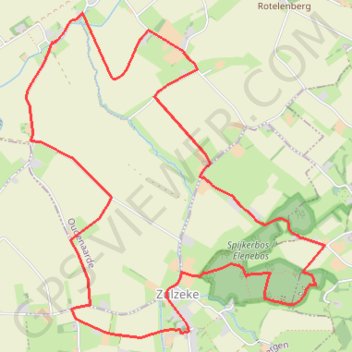
Zulzeke 9km
name=Zulzeke 9km
- Distance: 5.5 mi
- Elevation gain: 124 m
- Maximum elevation: 85 m
- Elevation loss: 124 m
- Minimum elevation: 12 m
Interactive trail map
Trail profile
- Distance: 5.5 mi
- Elevation gain: 124 m
- Maximum elevation: 85 m
- Elevation loss: 124 m
- Minimum elevation: 12 m
About this trail
Name: Zulzeke 9km trail, distance, elevation, map, profile, GPS track
Coordinates: 50.78859 3.55591 50.80768 3.58367
Other hiking, mountain biking, running and outdoor activity trails
Click on a trail to view its statistics, map and profile.
Ochtendrit
Belgium > East Flanders > Oudenaarde > Zwalm > Sint-Denijs-Boekel
Distance: 62.5 mi • Elevation gain: 335 m • Maximum elevation: 30 m
Zwalm-Doornik - 100K
Belgium > East Flanders > Oudenaarde > Zwalm > Sint-Denijs-Boekel
name=Zwalm-Doornik - 100K
Distance: 64.7 mi • Elevation gain: 347 m • Maximum elevation: 29 m
100K
Belgium > East Flanders > Oudenaarde > Oudenaarde
name=100K
Distance: 63.7 mi • Elevation gain: 595 m • Maximum elevation: 129 m
Ronde van Vlaanderen fietsroute blauwe lus
Belgium > East Flanders > Oudenaarde > Oudenaarde
Distance: 49.9 mi • Elevation gain: 816 m • Maximum elevation: 153 m