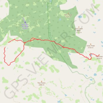
Import a GPX file

Red Peak

#Hiking #Loop #Eldorado

  • Distance: 15.5 mi
  • Elevation gain: 978 m
  • Maximum elevation: 2,810 m
  • Elevation loss: 968 m
  • Minimum elevation: 1,888 m

Interactive trail map

Trail profile

  • Distance: 15.5 mi
  • Elevation gain: 978 m
  • Maximum elevation: 2,810 m
  • Elevation loss: 968 m
  • Minimum elevation: 1,888 m

About this trail

Name: Red Peak trail, distance, elevation, map, profile, GPS track

Start: Forest Service Road 36, El Dorado County, California, United States (38.93135 -120.32125)

End: Forest Service Road 36, El Dorado County, California, United States (38.93546 -120.31803)

Coordinates: 38.91665 -120.32284 38.93937 -120.22133

Gear up for your next adventure:

🧤Hiking Gloves - Warm and durable gloves for cold-weather walks
🔦Outdoor Torches - Reliable torches for night navigation
🌦️Portable Weather Meters - Handheld tools for monitoring weather conditions
🥤Hiking Water Bottles - Reusable bottles for hydration on the trail
🎒Hiking Daypacks (20L) - Compact backpacks for day trips and technical mountain ascents

As an Amazon Associate, this site earns from qualifying purchases at no extra cost to you.