Thank you for supporting this site ❤️
Make a donation
Make a donation
Gear up for your next adventure:
As an Amazon Associate, this site earns from qualifying purchases at no extra cost to you.
Tannymorel - Bald Mountain
Interactive trail map
Thank you for supporting this site ❤️
Make a donation
Make a donation
Gear up for your next adventure:
As an Amazon Associate, this site earns from qualifying purchases at no extra cost to you.
Trail profile
- Distance: 36.7 mi
- Elevation gain: 1,460 m
- Maximum elevation: 1,194 m
- Elevation loss: 1,460 m
- Minimum elevation: 491 m
Thank you for supporting this site ❤️
Make a donation
Make a donation
Gear up for your next adventure:
As an Amazon Associate, this site earns from qualifying purchases at no extra cost to you.
About this trail
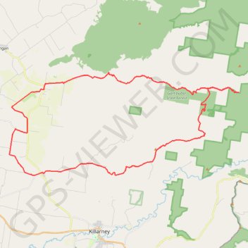
Name: Tannymorel - Bald Mountain trail, distance, elevation, map, profile, GPS track
Coordinates: -28.29309 152.21799 -28.21466 152.41654
Thank you for supporting this site ❤️
Make a donation
Make a donation
Gear up for your next adventure:
As an Amazon Associate, this site earns from qualifying purchases at no extra cost to you.
Other hiking, mountain biking, running and outdoor activity trails
Click on a trail to view its statistics, map and profile.
Warwick - Gatton
Australia > Queensland > Warwick
#Bike
Distance: 77.8 mi • Elevation gain: 812 m • Maximum elevation: 582 m