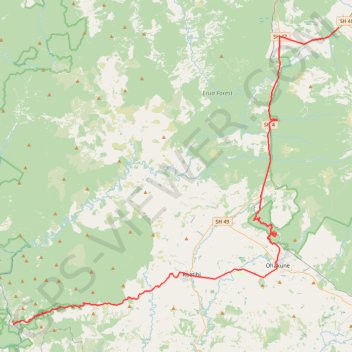
Tongariro - Pipiriki
Interactive trail map
Trail profile
- Distance: 50.7 mi
- Elevation gain: 988 m
- Maximum elevation: 889 m
- Elevation loss: 1,811 m
- Minimum elevation: 62 m
About this trail
Name: Tongariro - Pipiriki trail, distance, elevation, map, profile, GPS track
End: 11, Owairua Road, Pipiriki, Ruapehu District, Manawatū-Whanganui, New Zealand (-39.47871 175.04124)
Coordinates: -39.47881 175.04124 -39.16765 175.48277
Other hiking, mountain biking, running and outdoor activity trails
Click on a trail to view its statistics, map and profile.
Fishers Track
New Zealand > Manawatū-Whanganui > Ruapehu District > National Park
Distance: 17.1 mi • Elevation gain: 426 m • Maximum elevation: 850 m
Fishers Track
New Zealand > Manawatū-Whanganui > Ruapehu District > National Park
Distance: 17.1 mi • Elevation gain: 425 m • Maximum elevation: 850 m
Blyth Hut
New Zealand > Manawatū-Whanganui > Ruapehu District > Turoa Village
19-JUN-07
Distance: 15.2 mi • Elevation gain: 846 m • Maximum elevation: 1,728 m