Thank you for supporting this site ❤️
Make a donation
Make a donation
Gear up for your next adventure:
As an Amazon Associate, this site earns from qualifying purchases at no extra cost to you.
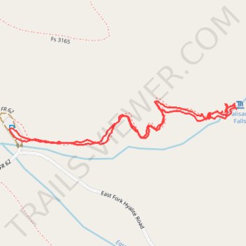
Palisade Falls Hiking Trail in Custer Gallatin National Forest
- Distance: 1.2 mi
- Elevation gain: 130 m
- Maximum elevation: 2,218 m
- Elevation loss: 130 m
- Minimum elevation: 2,104 m
- Moving time: 41 m 5 s
- Moving speed: 1.8 mph
- Maximum speed: 3.7 mph
- Total time: 55 m 43 s
- Global speed: 1.3 mph
Interactive trail map
Thank you for supporting this site ❤️
Make a donation
Make a donation
Gear up for your next adventure:
As an Amazon Associate, this site earns from qualifying purchases at no extra cost to you.
Trail profile
- Distance: 1.2 mi
- Elevation gain: 130 m
- Maximum elevation: 2,218 m
- Elevation loss: 130 m
- Minimum elevation: 2,104 m
- Moving time: 41 m 5 s
- Moving speed: 1.8 mph
- Maximum speed: 3.7 mph
- Total time: 55 m 43 s
- Global speed: 1.3 mph
Thank you for supporting this site ❤️
Make a donation
Make a donation
Gear up for your next adventure:
As an Amazon Associate, this site earns from qualifying purchases at no extra cost to you.
About this trail
Name: Palisade Falls Hiking Trail in Custer Gallatin National Forest trail, distance, elevation, map, profile, GPS track
Start: Hyalite Canyon Road, Gallatin County, Montana, United States (45.46875 -110.93906)
End: Hyalite Canyon Road, Gallatin County, Montana, United States (45.46872 -110.93904)
Coordinates: 45.46837 -110.93906 45.46944 -110.93108
Thank you for supporting this site ❤️
Make a donation
Make a donation
Gear up for your next adventure:
As an Amazon Associate, this site earns from qualifying purchases at no extra cost to you.