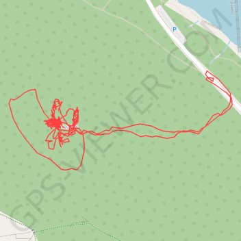
N 171887 3
- Distance: 2.2 mi
- Elevation gain: 150 m
- Maximum elevation: 346 m
- Elevation loss: 151 m
- Minimum elevation: 232 m
- Moving time: 1 h 29 m
- Moving speed: 1.5 mph
- Maximum speed: 3.0 mph
- Total time: 23 h 41 m
- Global speed: 0.1 mph
Interactive trail map
Trail profile
- Distance: 2.2 mi
- Elevation gain: 150 m
- Maximum elevation: 346 m
- Elevation loss: 151 m
- Minimum elevation: 232 m
- Moving time: 1 h 29 m
- Moving speed: 1.5 mph
- Maximum speed: 3.0 mph
- Total time: 23 h 41 m
- Global speed: 0.1 mph
About this trail
Name: N 171887 3 trail, distance, elevation, map, profile, GPS track
Coordinates: 53.39437 -1.74548 53.39618 -1.73864
Topography: High Peak topographic map, elevation, terrain
Other hiking, mountain biking, running and outdoor activity trails
Click on a trail to view its statistics, map and profile.
Peak District hike
United Kingdom > England > Derbyshire > High Peak > Edale > Grindsbrook Booth
Distance: 32.3 mi • Elevation gain: 1,325 m • Maximum elevation: 629 m
Peak District loop hike
United Kingdom > England > Derbyshire > High Peak > Hope
Distance: 22.6 mi • Elevation gain: 846 m • Maximum elevation: 632 m