Pine Mountain Wilderness Loop Hike
- Distance: 12.3 mi
- Elevation gain: 697 m
- Maximum elevation: 2,064 m
- Elevation loss: 711 m
- Minimum elevation: 1,555 m
- Moving time: 5 h 10 m
- Moving speed: 2.4 mph
- Maximum speed: 3.7 mph
- Total time: 6 h 12 m
- Global speed: 2.0 mph
Interactive trail map
Trail profile
- Distance: 12.3 mi
- Elevation gain: 697 m
- Maximum elevation: 2,064 m
- Elevation loss: 711 m
- Minimum elevation: 1,555 m
- Moving time: 5 h 10 m
- Moving speed: 2.4 mph
- Maximum speed: 3.7 mph
- Total time: 6 h 12 m
- Global speed: 2.0 mph
About this trail
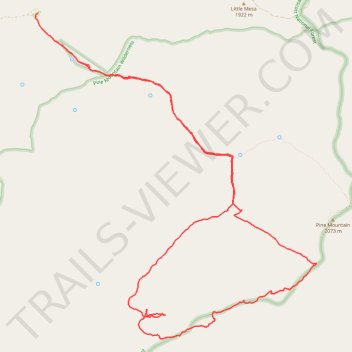
Name: Pine Mountain Wilderness Loop Hike trail, distance, elevation, map, profile, GPS track
Start: Nelson Trail, Yavapai County, Arizona, United States (34.32325 -111.83413)
End: Nelson Trail, Yavapai County, Arizona, United States (34.32640 -111.83611)
Coordinates: 34.28038 -111.83663 34.32640 -111.78839