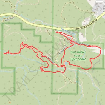
East Walker Ranch Open Space - Angeles National Forest
- Distance: 3.9 mi
- Elevation gain: 236 m
- Maximum elevation: 718 m
- Elevation loss: 236 m
- Minimum elevation: 591 m
- Moving time: 1 h 22 m
- Moving speed: 2.8 mph
- Maximum speed: 6.2 mph
- Total time: 1 h 42 m
- Global speed: 2.3 mph
Interactive trail map
Trail profile
- Distance: 3.9 mi
- Elevation gain: 236 m
- Maximum elevation: 718 m
- Elevation loss: 236 m
- Minimum elevation: 591 m
- Moving time: 1 h 22 m
- Moving speed: 2.8 mph
- Maximum speed: 6.2 mph
- Total time: 1 h 42 m
- Global speed: 2.3 mph
About this trail
Name: East Walker Ranch Open Space - Angeles National Forest trail, distance, elevation, map, profile, GPS track
Coordinates: 34.37002 -118.43947 34.37595 -118.42247
Other hiking, mountain biking, running and outdoor activity trails
Click on a trail to view its statistics, map and profile.
East Walker Ranch - Keely Trail Downhill
United States > California > Los Angeles County > Santa Clarita
Distance: 1.4 mi • Elevation gain: 79 m • Maximum elevation: 687 m
Walker Ranch Open Space
United States > California > Los Angeles County > Santa Clarita
Distance: 3.7 mi • Elevation gain: 199 m • Maximum elevation: 686 m