Thank you for supporting this site ❤️
Make a donation
Make a donation
Gear up for your next adventure:
As an Amazon Associate, this site earns from qualifying purchases at no extra cost to you.
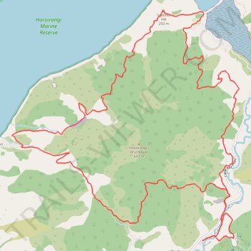
Horoirangi / Drumduan Loop via Cable Bay Walkway and Overlook
- Distance: 15.9 mi
- Elevation gain: 1,488 m
- Maximum elevation: 408 m
- Elevation loss: 1,487 m
- Minimum elevation: 8 m
- Moving time: 4 h 47 m
- Moving speed: 3.3 mph
- Maximum speed: 10.4 mph
- Total time: 5 h 16 m
- Global speed: 3.0 mph
Interactive trail map
Thank you for supporting this site ❤️
Make a donation
Make a donation
Gear up for your next adventure:
As an Amazon Associate, this site earns from qualifying purchases at no extra cost to you.
Trail profile
- Distance: 15.9 mi
- Elevation gain: 1,488 m
- Maximum elevation: 408 m
- Elevation loss: 1,487 m
- Minimum elevation: 8 m
- Moving time: 4 h 47 m
- Moving speed: 3.3 mph
- Maximum speed: 10.4 mph
- Total time: 5 h 16 m
- Global speed: 3.0 mph
Thank you for supporting this site ❤️
Make a donation
Make a donation
Gear up for your next adventure:
As an Amazon Associate, this site earns from qualifying purchases at no extra cost to you.
About this trail
Name: Horoirangi / Drumduan Loop via Cable Bay Walkway and Overlook trail, distance, elevation, map, profile, GPS track
Start: 194, Cable Bay Road, Hira, Nelson, New Zealand (-41.20175 173.41328)
End: 194, Cable Bay Road, Hira, Nelson, New Zealand (-41.20174 173.41321)
Coordinates: -41.20193 173.36732 -41.15989 173.42210
Thank you for supporting this site ❤️
Make a donation
Make a donation
Gear up for your next adventure:
As an Amazon Associate, this site earns from qualifying purchases at no extra cost to you.