Mount Cooroora
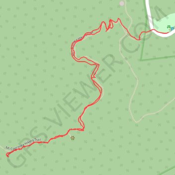
Interactive trail map
Trail profile
- Distance: 1.5 mi
- Elevation gain: 225 m
- Maximum elevation: 386 m
- Elevation loss: 255 m
- Minimum elevation: 130 m
- Moving time: 52 m 2 s
- Moving speed: 1.8 mph
- Maximum speed: 5.3 mph
- Total time: 1 h 43 m
- Global speed: 0.9 mph
About this trail
Name: Mount Cooroora trail, distance, elevation, map, profile, GPS track
Start: Mt Cooroora Hiking Trail, Pomona, Noosa Shire, Queensland, 4568, Australia (-26.36780 152.84267)
End: Mountain Street, Pomona, Noosa Shire, Queensland, 4568, Australia (-26.36795 152.84480)
Coordinates: -26.37201 152.83891 -26.36749 152.84480
Other hiking, mountain biking, running and outdoor activity trails
Click on a trail to view its statistics, map and profile.
2026-07-14_02-27_Tue
Australia > Queensland > Brisbane
Distance: 252.4 mi • Elevation gain: 3,756 m • Maximum elevation: 171 m
Kandanga Wrattens Widgee Loop
Australia > Queensland > Tewantin
Distance: 136.9 mi • Elevation gain: 3,584 m • Maximum elevation: 684 m
Yurol area ride trace
Australia > Queensland > Tewantin
Distance: 42.3 mi • Elevation gain: 769 m • Maximum elevation: 175 m
Noosa Enduro MTB Course
Australia > Queensland > Tewantin
Distance: 56.9 mi • Elevation gain: 1,691 m • Maximum elevation: 460 m