Thank you for supporting this site ❤️
Make a donation
Make a donation
Gear up for your next adventure:
As an Amazon Associate, this site earns from qualifying purchases at no extra cost to you.
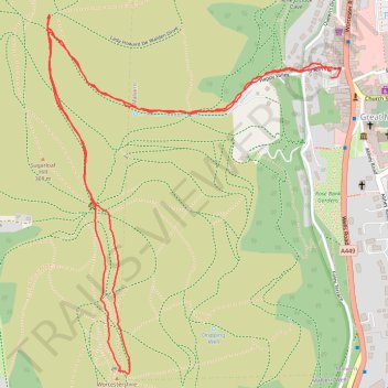
Malvern Hills Walk to Worcestershire Beacon
- Distance: 2.5 mi
- Elevation gain: 265 m
- Maximum elevation: 422 m
- Elevation loss: 266 m
- Minimum elevation: 155 m
- Moving time: 1 h 22 m
- Moving speed: 1.8 mph
- Maximum speed: 6.9 mph
- Total time: 1 h 42 m
- Global speed: 1.4 mph
Interactive trail map
Thank you for supporting this site ❤️
Make a donation
Make a donation
Gear up for your next adventure:
As an Amazon Associate, this site earns from qualifying purchases at no extra cost to you.
Trail profile
- Distance: 2.5 mi
- Elevation gain: 265 m
- Maximum elevation: 422 m
- Elevation loss: 266 m
- Minimum elevation: 155 m
- Moving time: 1 h 22 m
- Moving speed: 1.8 mph
- Maximum speed: 6.9 mph
- Total time: 1 h 42 m
- Global speed: 1.4 mph
Thank you for supporting this site ❤️
Make a donation
Make a donation
Gear up for your next adventure:
As an Amazon Associate, this site earns from qualifying purchases at no extra cost to you.
About this trail
Name: Malvern Hills Walk to Worcestershire Beacon trail, distance, elevation, map, profile, GPS track
Coordinates: 52.10494 -2.34159 52.11337 -2.33040
Topography: Malvern Hills topographic map, elevation, terrain
Thank you for supporting this site ❤️
Make a donation
Make a donation
Gear up for your next adventure:
As an Amazon Associate, this site earns from qualifying purchases at no extra cost to you.