Thank you for supporting this site ❤️
Make a donation
Make a donation
Gear up for your next adventure:
As an Amazon Associate, this site earns from qualifying purchases at no extra cost to you.
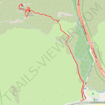
Gaviota Wind Caves
- Distance: 3.0 mi
- Elevation gain: 235 m
- Maximum elevation: 185 m
- Elevation loss: 254 m
- Minimum elevation: 4 m
- Moving time: 1 h 31 m
- Moving speed: 2.0 mph
- Maximum speed: 22.3 mph
- Total time: 2 h 34 m
- Global speed: 1.2 mph
Interactive trail map
Thank you for supporting this site ❤️
Make a donation
Make a donation
Gear up for your next adventure:
As an Amazon Associate, this site earns from qualifying purchases at no extra cost to you.
Trail profile
- Distance: 3.0 mi
- Elevation gain: 235 m
- Maximum elevation: 185 m
- Elevation loss: 254 m
- Minimum elevation: 4 m
- Moving time: 1 h 31 m
- Moving speed: 2.0 mph
- Maximum speed: 22.3 mph
- Total time: 2 h 34 m
- Global speed: 1.2 mph
Thank you for supporting this site ❤️
Make a donation
Make a donation
Gear up for your next adventure:
As an Amazon Associate, this site earns from qualifying purchases at no extra cost to you.
About this trail
Name: Gaviota Wind Caves trail, distance, elevation, map, profile, GPS track
Start: Beach to Backcountry Trail, Santa Barbara County, California, United States (34.47184 -120.22972)
End: Gaviota Beach Road, Santa Barbara County, California, United States (34.47381 -120.22931)
Coordinates: 34.47157 -120.23897 34.48307 -120.22931
Thank you for supporting this site ❤️
Make a donation
Make a donation
Gear up for your next adventure:
As an Amazon Associate, this site earns from qualifying purchases at no extra cost to you.