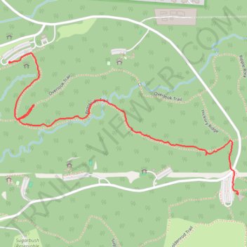
Brookside Trail
- Distance: 1.1 mi
- Elevation gain: 11 m
- Maximum elevation: 291 m
- Elevation loss: 26 m
- Minimum elevation: 270 m
- Moving time: 26 m 49 s
- Moving speed: 2.5 mph
- Maximum speed: 4.2 mph
- Total time: 41 m 34 s
- Global speed: 1.6 mph
Interactive trail map
Trail profile
- Distance: 1.1 mi
- Elevation gain: 11 m
- Maximum elevation: 291 m
- Elevation loss: 26 m
- Minimum elevation: 270 m
- Moving time: 26 m 49 s
- Moving speed: 2.5 mph
- Maximum speed: 4.2 mph
- Total time: 41 m 34 s
- Global speed: 1.6 mph
About this trail
Name: Brookside Trail trail, distance, elevation, map, profile, GPS track
Start: Sugarbush Trail, Columbus, Sharon, Franklin County, Ohio, 43230, United States (40.07060 -82.87327)
End: Brookside Trail, Columbus, Sharon, Franklin County, Ohio, 02070, United States (40.07505 -82.88324)
Coordinates: 40.07058 -82.88326 40.07533 -82.87319
Other hiking, mountain biking, running and outdoor activity trails
Click on a trail to view its statistics, map and profile.
Overlook Trail, Ripple Rock and Lake Trail in Blendon Woods Metro Park
United States > Ohio > Franklin County > Columbus
Distance: 1.5 mi • Elevation gain: 28 m • Maximum elevation: 297 m