Thank you for supporting this site ❤️
Make a donation
Make a donation
Gear up for your next adventure:
As an Amazon Associate, this site earns from qualifying purchases at no extra cost to you.
Te Ahumairangi Reserve Loop Walk
- Distance: 2.8 mi
- Elevation gain: 255 m
- Maximum elevation: 284 m
- Elevation loss: 256 m
- Minimum elevation: 139 m
- Moving time: 1 h 9 m
- Moving speed: 2.4 mph
- Maximum speed: 4.9 mph
- Total time: 1 h 45 m
- Global speed: 1.6 mph
Interactive trail map
Thank you for supporting this site ❤️
Make a donation
Make a donation
Gear up for your next adventure:
As an Amazon Associate, this site earns from qualifying purchases at no extra cost to you.
Trail profile
- Distance: 2.8 mi
- Elevation gain: 255 m
- Maximum elevation: 284 m
- Elevation loss: 256 m
- Minimum elevation: 139 m
- Moving time: 1 h 9 m
- Moving speed: 2.4 mph
- Maximum speed: 4.9 mph
- Total time: 1 h 45 m
- Global speed: 1.6 mph
Thank you for supporting this site ❤️
Make a donation
Make a donation
Gear up for your next adventure:
As an Amazon Associate, this site earns from qualifying purchases at no extra cost to you.
About this trail
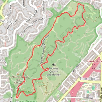
Name: Te Ahumairangi Reserve Loop Walk trail, distance, elevation, map, profile, GPS track
Coordinates: -41.27698 174.76400 -41.26540 174.77524
Thank you for supporting this site ❤️
Make a donation
Make a donation
Gear up for your next adventure:
As an Amazon Associate, this site earns from qualifying purchases at no extra cost to you.
Other hiking, mountain biking, running and outdoor activity trails
Click on a trail to view its statistics, map and profile.
Welington
New Zealand > Wellington > Wellington City > Wellington
Distance: 46.3 mi • Elevation gain: 886 m • Maximum elevation: 223 m