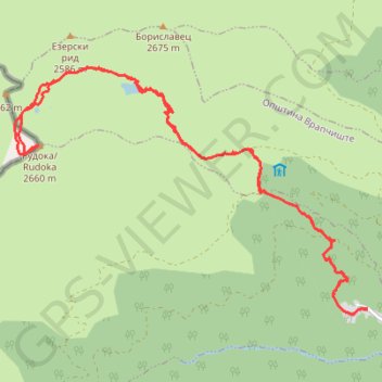
Lomnica-Crno ezero-Rudoka
- Distance: 13.2 mi
- Elevation gain: 1,727 m
- Maximum elevation: 2,649 m
- Elevation loss: 1,730 m
- Minimum elevation: 945 m
Interactive trail map
Trail profile
- Distance: 13.2 mi
- Elevation gain: 1,727 m
- Maximum elevation: 2,649 m
- Elevation loss: 1,730 m
- Minimum elevation: 945 m
About this trail
Name: Lomnica-Crno ezero-Rudoka trail, distance, elevation, map, profile, GPS track
Start: Lomnica, Gjurgjevishte, Municipality of Vrapchishte, 1235, North Macedonia (41.89639 20.83578)
End: Lomnica, Gjurgjevishte, Municipality of Vrapchishte, 1235, North Macedonia (41.89634 20.83574)
Coordinates: 41.89563 20.77183 41.92904 20.83578
Other hiking, mountain biking, running and outdoor activity trails
Click on a trail to view its statistics, map and profile.
Rudoka i Crno Ezero (Šar Planina)
North Macedonia > Gjurgjevishte > Lomnica
Distance: 12.7 mi • Elevation gain: 1,720 m • Maximum elevation: 2,649 m
Vrapchishte Piesze wędrówki
North Macedonia > Gjurgjevishte
Distance: 19.1 mi • Elevation gain: 2,124 m • Maximum elevation: 2,656 m