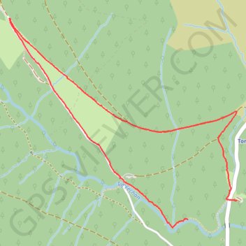
Pen y Fan paths
- Distance: 2.5 mi
- Elevation gain: 87 m
- Maximum elevation: 430 m
- Elevation loss: 84 m
- Minimum elevation: 343 m
- Moving time: 48 m 43 s
- Moving speed: 3.1 mph
- Maximum speed: 4.5 mph
- Total time: 48 m 43 s
- Global speed: 3.1 mph
Interactive trail map
Trail profile
- Distance: 2.5 mi
- Elevation gain: 87 m
- Maximum elevation: 430 m
- Elevation loss: 84 m
- Minimum elevation: 343 m
- Moving time: 48 m 43 s
- Moving speed: 3.1 mph
- Maximum speed: 4.5 mph
- Total time: 48 m 43 s
- Global speed: 3.1 mph
About this trail
Name: Pen y Fan paths trail, distance, elevation, map, profile, GPS track
Start: Talybont-on-Usk, Powys, Wales, CF48 2UT, United Kingdom (51.83576 -3.38628)
Coordinates: 51.83531 -3.40165 51.84643 -3.38206
Topography: Powys topographic map, elevation, terrain
Other hiking, mountain biking, running and outdoor activity trails
Click on a trail to view its statistics, map and profile.
The Headstock 500
United Kingdom > Wales > Newport > Newport
Distance: 300.4 mi • Elevation gain: 9,616 m • Maximum elevation: 691 m
Treorchy, Cearphilly, Pen y Fan
United Kingdom > Wales > Caerphilly County Borough > Tredegar
Distance: 79.1 mi • Elevation gain: 1,934 m • Maximum elevation: 501 m