Broad River Greenway Escape
- Distance: 6.6 mi
- Elevation gain: 192 m
- Maximum elevation: 258 m
- Elevation loss: 192 m
- Minimum elevation: 198 m
- Moving time: 2 h 16 m
- Moving speed: 2.9 mph
- Maximum speed: 7.3 mph
- Total time: 3 h 5 m
- Global speed: 2.1 mph
Interactive trail map
Trail profile
- Distance: 6.6 mi
- Elevation gain: 192 m
- Maximum elevation: 258 m
- Elevation loss: 192 m
- Minimum elevation: 198 m
- Moving time: 2 h 16 m
- Moving speed: 2.9 mph
- Maximum speed: 7.3 mph
- Total time: 3 h 5 m
- Global speed: 2.1 mph
About this trail
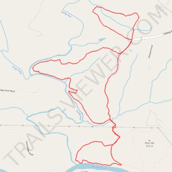
Name: Broad River Greenway Escape trail, distance, elevation, map, profile, GPS track
Coordinates: 35.21519 -81.70218 35.23762 -81.68385
Other hiking, mountain biking, running and outdoor activity trails
Click on a trail to view its statistics, map and profile.
Broad River Greenway Trails
United States > North Carolina > Cleveland County > Boiling Springs
Distance: 6.3 mi • Elevation gain: 191 m • Maximum elevation: 253 m