Make a donation
Gear up for your next adventure:
As an Amazon Associate, this site earns from qualifying purchases at no extra cost to you.
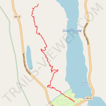
Thunder Knob Trail in Ross Lake National Recreation Area
The Thunder Knob Trail in Washington's Ross Lake National Recreation Area offers a delightful hiking experience suitable for families and casual hikers. The path meanders through a lush forest of Douglas-fir, red cedar, and western hemlock, providing a cool and shaded environment. As you ascend, the trail opens up to reveal stunning vistas of Diablo Lake's turquoise waters, framed by the rugged peaks of Davis Peak, Ruby Mountain and Jack Mountain. The well-maintained trail features benches at scenic viewpoints, allowing hikers to pause and fully appreciate the breathtaking surroundings. #Hiking #Mountain #Forest #Nature #Lake #Overlook
- Distance: 3.6 mi
- Elevation gain: 206 m
- Maximum elevation: 563 m
- Elevation loss: 206 m
- Minimum elevation: 378 m
- Moving time: 1 h 35 m
- Moving speed: 2.3 mph
- Maximum speed: 3.9 mph
- Total time: 1 h 43 m
- Global speed: 2.1 mph
Interactive trail map
Make a donation
Gear up for your next adventure:
As an Amazon Associate, this site earns from qualifying purchases at no extra cost to you.
Trail profile
- Distance: 3.6 mi
- Elevation gain: 206 m
- Maximum elevation: 563 m
- Elevation loss: 206 m
- Minimum elevation: 378 m
- Moving time: 1 h 35 m
- Moving speed: 2.3 mph
- Maximum speed: 3.9 mph
- Total time: 1 h 43 m
- Global speed: 2.1 mph
Make a donation
Gear up for your next adventure:
As an Amazon Associate, this site earns from qualifying purchases at no extra cost to you.
About this trail
Name: Thunder Knob Trail in Ross Lake National Recreation Area trail, distance, elevation, map, profile, GPS track
Coordinates: 48.69050 -121.10810 48.70473 -121.09870
Make a donation
Gear up for your next adventure:
As an Amazon Associate, this site earns from qualifying purchases at no extra cost to you.
Other hiking, mountain biking, running and outdoor activity trails
Click on a trail to view its statistics, map and profile.
Northern part of the Pacific Crest Trail (PCT)
United States > Oregon > Klamath County
Hike on the Pacific Crest National Scenic Trail from Crater Lake to Canada Border through Oregon and Washington along the Sierra Nevada and Cascade mountain ranges. #Hiking #Mountain #SierraNevada #Cascade #Nature #Forest #Park #PCT
Distance: 744.6 mi • Elevation gain: 44,308 m • Maximum elevation: 2,307 m