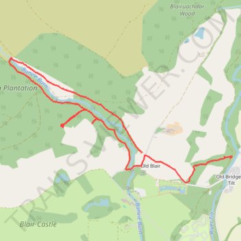
Walk near Old Blair
- Distance: 3.9 mi
- Elevation gain: 174 m
- Maximum elevation: 278 m
- Elevation loss: 163 m
- Minimum elevation: 170 m
- Moving time: 1 h 36 m
- Moving speed: 2.4 mph
- Maximum speed: 5.4 mph
- Total time: 1 h 50 m
- Global speed: 2.1 mph
Interactive trail map
Trail profile
About this trail
Name: Walk near Old Blair trail, distance, elevation, map, profile, GPS track
Coordinates: 56.77526 -3.87819 56.78712 -3.83946
Topography: Perth and Kinross topographic map, elevation, terrain