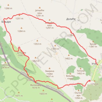
Pešter: Žilindar (1616m), Štedim (1500m)
- Distance: 11.8 mi
- Elevation gain: 687 m
- Maximum elevation: 1,611 m
- Elevation loss: 752 m
- Minimum elevation: 1,164 m
Interactive trail map
Trail profile
- Distance: 11.8 mi
- Elevation gain: 687 m
- Maximum elevation: 1,611 m
- Elevation loss: 752 m
- Minimum elevation: 1,164 m
About this trail
Name: Pešter: Žilindar (1616m), Štedim (1500m) trail, distance, elevation, map, profile, GPS track
Coordinates: 43.03917 19.98763 43.08137 20.06012
Other hiking, mountain biking, running and outdoor activity trails
Click on a trail to view its statistics, map and profile.
2022_Yu
Slovenia > Ajdovščina > Žapuže
Distance: 1,526.9 mi • Elevation gain: 32,048 m • Maximum elevation: 1,950 m