Make a donation
Gear up for your next adventure:
As an Amazon Associate, this site earns from qualifying purchases at no extra cost to you.
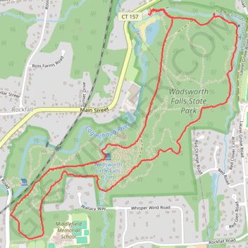
Wadsworth Falls Loop Trail in Wadsworth Falls State Park
The Wadsworth Falls Loop Trail offers a scenic journey through a beautiful wooded landscape, making it an ideal destination for nature enthusiasts. Hikers can enjoy picturesque views of the impressive Wadsworth Falls, a striking 30-foot waterfall, as well as smaller cascades along the route, which are particularly captivating after rainfall. The trail is well-marked and suitable for families, providing a peaceful atmosphere and opportunities for birdwatching, with the backdrop of the Coginchaug River enhancing the overall experience. #Hiking #Loop #Waterfall #Forest #Nature
- Distance: 3.7 mi
- Elevation gain: 92 m
- Maximum elevation: 79 m
- Elevation loss: 91 m
- Minimum elevation: 24 m
- Moving time: 1 h 28 m
- Moving speed: 2.5 mph
- Maximum speed: 3.6 mph
- Total time: 1 h 41 m
- Global speed: 2.2 mph
Interactive trail map
Make a donation
Gear up for your next adventure:
As an Amazon Associate, this site earns from qualifying purchases at no extra cost to you.
Trail profile
- Distance: 3.7 mi
- Elevation gain: 92 m
- Maximum elevation: 79 m
- Elevation loss: 91 m
- Minimum elevation: 24 m
- Moving time: 1 h 28 m
- Moving speed: 2.5 mph
- Maximum speed: 3.6 mph
- Total time: 1 h 41 m
- Global speed: 2.2 mph
Make a donation
Gear up for your next adventure:
As an Amazon Associate, this site earns from qualifying purchases at no extra cost to you.
About this trail
Name: Wadsworth Falls Loop Trail in Wadsworth Falls State Park trail, distance, elevation, map, profile, GPS track
Coordinates: 41.52289 -72.69681 41.53675 -72.67856
Make a donation
Gear up for your next adventure:
As an Amazon Associate, this site earns from qualifying purchases at no extra cost to you.