Import a GPX file

Brant Park Conservation Area - Grand River

#Hiking #Bike #Running #Loop #Brant

  • Distance: 9.7 mi
  • Elevation gain: 77 m
  • Maximum elevation: 221 m
  • Elevation loss: 77 m
  • Minimum elevation: 201 m

Interactive trail map

Trail profile

  • Distance: 9.7 mi
  • Elevation gain: 77 m
  • Maximum elevation: 221 m
  • Elevation loss: 77 m
  • Minimum elevation: 201 m

About this trail

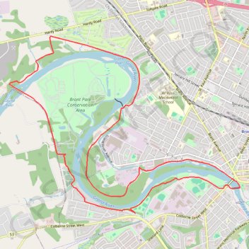
Name: Brant Park Conservation Area - Grand River trail, distance, elevation, map, profile, GPS track

Start: 290, Dufferin Avenue, Holmedale, Brantford, Ontario, N3T 5B1, Canada (43.15025 -80.29233)

End: 290, Dufferin Avenue, Holmedale, Brantford, Ontario, N3T 5B1, Canada (43.15025 -80.29233)

Coordinates: 43.13216 -80.32021 43.16145 -80.26793

Gear up for your next adventure:

🎒Replacement Sternum Straps - Repair parts for hiking rucksacks
Lightweight Tents - Compact tents for backpacking and trekking
🥾Women's Waterproof Hiking Boots - High-performance trekking boots designed for all-weather comfort
🍲Portable Camping Stoves - Fast-boiling stoves for hot meals on remote topographic survey trips
🥄Titanium Camping Sporks - The ultimate lightweight utensil for trail meals

As an Amazon Associate, this site earns from qualifying purchases at no extra cost to you.