The Courtyard at Fitchburg
- Distance: 1.3 mi
- Elevation gain: 7 m
- Maximum elevation: 283 m
- Elevation loss: 7 m
- Minimum elevation: 279 m
- Moving time: 10 m 13 s
- Moving speed: 7.9 mph
- Maximum speed: 12.5 mph
- Total time: 11 m 1 s
- Global speed: 7.3 mph
Interactive trail map
Trail profile
- Distance: 1.3 mi
- Elevation gain: 7 m
- Maximum elevation: 283 m
- Elevation loss: 7 m
- Minimum elevation: 279 m
- Moving time: 10 m 13 s
- Moving speed: 7.9 mph
- Maximum speed: 12.5 mph
- Total time: 11 m 1 s
- Global speed: 7.3 mph
About this trail
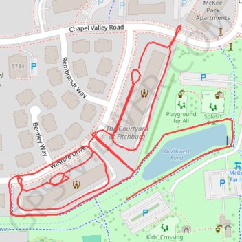
Name: The Courtyard at Fitchburg trail, distance, elevation, map, profile, GPS track
Coordinates: 43.01154 -89.43634 43.01420 -89.43206
Other hiking, mountain biking, running and outdoor activity trails
Click on a trail to view its statistics, map and profile.
Paoli via Southwest Bike Path, Badger State Trail and Military Ridge State Trail
United States > Wisconsin > Dane County > Madison
Distance: 26.9 mi • Elevation gain: 288 m • Maximum elevation: 323 m
Belleville via Southwest Bike Path and Badger State Trail
United States > Wisconsin > Dane County > Madison
Distance: 37.8 mi • Elevation gain: 354 m • Maximum elevation: 340 m