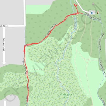
Purgatory Park Trail
- Distance: 0.9 mi
- Elevation gain: 14 m
- Maximum elevation: 277 m
- Elevation loss: 14 m
- Minimum elevation: 268 m
- Moving time: 17 m 33 s
- Moving speed: 3.0 mph
- Maximum speed: 4.8 mph
- Total time: 18 m 37 s
- Global speed: 2.8 mph
Interactive trail map
Trail profile
- Distance: 0.9 mi
- Elevation gain: 14 m
- Maximum elevation: 277 m
- Elevation loss: 14 m
- Minimum elevation: 268 m
- Moving time: 17 m 33 s
- Moving speed: 3.0 mph
- Maximum speed: 4.8 mph
- Total time: 18 m 37 s
- Global speed: 2.8 mph
About this trail
Name: Purgatory Park Trail trail, distance, elevation, map, profile, GPS track
Coordinates: 44.90108 -93.50335 44.90538 -93.49964
Other hiking, mountain biking, running and outdoor activity trails
Click on a trail to view its statistics, map and profile.
Purgatory Park Loop Trail
United States > Minnesota > Hennepin County > Minnetonka
Distance: 1.3 mi • Elevation gain: 23 m • Maximum elevation: 281 m