Lost Lake from Hessie Trailhead via Devil's Thumb Trail in Roosevelt National Forest
This trail offers a pleasant walk through forested terrain, with the steady sound of a nearby creek and a few waterfalls to enjoy along the way. The slightly uphill trail leads to Lost Lake, a peaceful spot that's perfect for a break before heading back. #Hiking #Mountain #Lake #River #Waterfall #Forest #Nature
- Distance: 4.4 mi
- Elevation gain: 268 m
- Maximum elevation: 2,993 m
- Elevation loss: 267 m
- Minimum elevation: 2,732 m
- Moving time: 2 h 6 m
- Moving speed: 2.1 mph
- Maximum speed: 3.8 mph
- Total time: 2 h 25 m
- Global speed: 1.8 mph
Interactive trail map
Trail profile
- Distance: 4.4 mi
- Elevation gain: 268 m
- Maximum elevation: 2,993 m
- Elevation loss: 267 m
- Minimum elevation: 2,732 m
- Moving time: 2 h 6 m
- Moving speed: 2.1 mph
- Maximum speed: 3.8 mph
- Total time: 2 h 25 m
- Global speed: 1.8 mph
About this trail
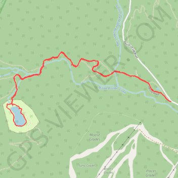
Name: Lost Lake from Hessie Trailhead via Devil's Thumb Trail in Roosevelt National Forest trail, distance, elevation, map, profile, GPS track
Start: Hessie Road, Boulder County, Colorado, 80474, United States (39.95151 -105.59486)
End: Hessie Road, Boulder County, Colorado, 80474, United States (39.95155 -105.59495)
Coordinates: 39.94886 -105.61812 39.95693 -105.59486
Other hiking, mountain biking, running and outdoor activity trails
Click on a trail to view its statistics, map and profile.