Thank you for supporting this site ❤️
Make a donation
Make a donation
Gear up for your next adventure:
As an Amazon Associate, this site earns from qualifying purchases at no extra cost to you.
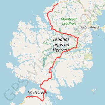
Hebridean Way
- Distance: 63.5 mi
- Elevation gain: 1,332 m
- Maximum elevation: 200 m
- Elevation loss: 1,309 m
- Minimum elevation: 0 m
- Moving time: 7 h 6 m
- Moving speed: 8.9 mph
- Maximum speed: 35.0 mph
- Total time: 9 h 30 m
- Global speed: 6.7 mph
Interactive trail map
Thank you for supporting this site ❤️
Make a donation
Make a donation
Gear up for your next adventure:
As an Amazon Associate, this site earns from qualifying purchases at no extra cost to you.
Trail profile
- Distance: 63.5 mi
- Elevation gain: 1,332 m
- Maximum elevation: 200 m
- Elevation loss: 1,309 m
- Minimum elevation: 0 m
- Moving time: 7 h 6 m
- Moving speed: 8.9 mph
- Maximum speed: 35.0 mph
- Total time: 9 h 30 m
- Global speed: 6.7 mph
Thank you for supporting this site ❤️
Make a donation
Make a donation
Gear up for your next adventure:
As an Amazon Associate, this site earns from qualifying purchases at no extra cost to you.
About this trail
Name: Hebridean Way trail, distance, elevation, map, profile, GPS track
Coordinates: 57.84621 -6.97980 58.32104 -6.49592
Topography: Western Isles topographic map, elevation, terrain
Thank you for supporting this site ❤️
Make a donation
Make a donation
Gear up for your next adventure:
As an Amazon Associate, this site earns from qualifying purchases at no extra cost to you.