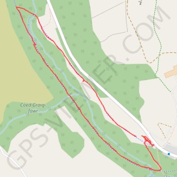
Cwm Darran bottom
- Distance: 1.4 mi
- Elevation gain: 38 m
- Maximum elevation: 228 m
- Elevation loss: 37 m
- Minimum elevation: 203 m
- Moving time: 31 m 52 s
- Moving speed: 2.7 mph
- Maximum speed: 4.6 mph
- Total time: 33 m 12 s
- Global speed: 2.6 mph
Interactive trail map
Trail profile
- Distance: 1.4 mi
- Elevation gain: 38 m
- Maximum elevation: 228 m
- Elevation loss: 37 m
- Minimum elevation: 203 m
- Moving time: 31 m 52 s
- Moving speed: 2.7 mph
- Maximum speed: 4.6 mph
- Total time: 33 m 12 s
- Global speed: 2.6 mph
About this trail
Name: Cwm Darran bottom trail, distance, elevation, map, profile, GPS track
Start: Darran Valley, Deri, Caerphilly County Borough, Wales, CF81 9GH, United Kingdom (51.69684 -3.25092)
Coordinates: 51.69548 -3.25874 51.70208 -3.24931
Topography: Caerphilly County Borough topographic map, elevation, terrain
Other hiking, mountain biking, running and outdoor activity trails
Click on a trail to view its statistics, map and profile.
The Headstock 500
United Kingdom > Wales > Newport > Newport
Distance: 300.4 mi • Elevation gain: 9,616 m • Maximum elevation: 691 m
Treorchy, Cearphilly, Pen y Fan
United Kingdom > Wales > Caerphilly County Borough > Tredegar
Distance: 79.1 mi • Elevation gain: 1,934 m • Maximum elevation: 501 m
Cwm Darren
United Kingdom > Wales > Caerphilly County Borough > Deri
Distance: 5.0 mi • Elevation gain: 100 m • Maximum elevation: 296 m