Make a donation
Gear up for your next adventure:
As an Amazon Associate, this site earns from qualifying purchases at no extra cost to you.
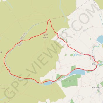
Pendle Hill Loop
Loop hike from Barley via Pendle Hill, Ogden Clough, Upper Ogden Reservoir, Buttock Plantation and Lower Ogden Reservoir in the Forest of Bowland National Landscape. #Hiking #Loop #Nature #Countryside #River #Lake #Forest
- Distance: 5.9 mi
- Elevation gain: 346 m
- Maximum elevation: 557 m
- Elevation loss: 344 m
- Minimum elevation: 220 m
- Moving time: 2 h 54 m
- Moving speed: 2.0 mph
- Maximum speed: 4.6 mph
- Total time: 3 h 10 m
- Global speed: 1.9 mph
Interactive trail map
Make a donation
Gear up for your next adventure:
As an Amazon Associate, this site earns from qualifying purchases at no extra cost to you.
Trail profile
- Distance: 5.9 mi
- Elevation gain: 346 m
- Maximum elevation: 557 m
- Elevation loss: 344 m
- Minimum elevation: 220 m
- Moving time: 2 h 54 m
- Moving speed: 2.0 mph
- Maximum speed: 4.6 mph
- Total time: 3 h 10 m
- Global speed: 1.9 mph
Make a donation
Gear up for your next adventure:
As an Amazon Associate, this site earns from qualifying purchases at no extra cost to you.
About this trail
Name: Pendle Hill Loop trail, distance, elevation, map, profile, GPS track
Coordinates: 53.85239 -2.32087 53.87251 -2.26992
Topography: Borough of Pendle topographic map, elevation, terrain
Make a donation
Gear up for your next adventure:
As an Amazon Associate, this site earns from qualifying purchases at no extra cost to you.
Other hiking, mountain biking, running and outdoor activity trails
Click on a trail to view its statistics, map and profile.
Up and down Pendle Hill
United Kingdom > England > Lancashire > Borough of Pendle > Barley
Distance: 4.3 mi • Elevation gain: 339 m • Maximum elevation: 558 m