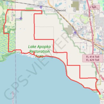
Import a GPX file

Lake Apopka

#Bike #Loop

  • Distance: 28.0 mi
  • Elevation gain: 58 m
  • Maximum elevation: 34 m
  • Elevation loss: 56 m
  • Minimum elevation: 18 m

Interactive trail map

Trail profile

  • Distance: 28.0 mi
  • Elevation gain: 58 m
  • Maximum elevation: 34 m
  • Elevation loss: 56 m
  • Minimum elevation: 18 m

About this trail

Other hiking, mountain biking, running and outdoor activity trails

Click on a trail to view its statistics, map and profile.

Lake Apopka

United States > Florida > Orange County

#Bike #Loop

Distance: 12.6 mi • Elevation gain: 41 m • Maximum elevation: 40 m

Gear up for your next adventure:

Lightweight Tents - Compact tents for backpacking and trekking
📚UK Hiking Guidebooks - Detailed route descriptions for the Lake District, Peaks, and Highlands
🗺️Topographic Maps - Detailed maps showing elevation and terrain features
🎒Hiking Daypacks - Compact backpacks ideal for short hikes and excursions
🖼️Topographic Map Art - Decorative 3D-effect posters of famous UK peaks and regions

As an Amazon Associate, this site earns from qualifying purchases at no extra cost to you.