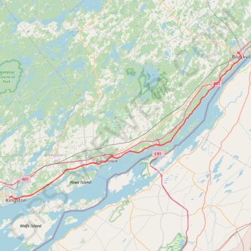
Kingstone - Brockville
#Bike
- Distance: 52.9 mi
- Elevation gain: 469 m
- Maximum elevation: 110 m
- Elevation loss: 469 m
- Minimum elevation: 75 m
Interactive trail map
Trail profile
- Distance: 52.9 mi
- Elevation gain: 469 m
- Maximum elevation: 110 m
- Elevation loss: 469 m
- Minimum elevation: 75 m
About this trail
Name: Kingstone - Brockville trail, distance, elevation, map, profile, GPS track
Coordinates: 44.23361 -76.50398 44.60041 -75.68903
Other hiking, mountain biking, running and outdoor activity trails
Click on a trail to view its statistics, map and profile.
Brockville - Lancaster
Canada > Ontario > Brockville > Brockville
Saint-Laurent River. #Bike #SaintLaurent
Distance: 84.1 mi • Elevation gain: 489 m • Maximum elevation: 101 m
Brockville - Ottawa
Canada > Ontario > Brockville > Brockville
#Bike #Brockville #Ottawa
Distance: 73.6 mi • Elevation gain: 375 m • Maximum elevation: 134 m
Brockville - Cornwall
Canada > Ontario > Brockville > Brockville
#Bike
Distance: 62.2 mi • Elevation gain: 298 m • Maximum elevation: 102 m