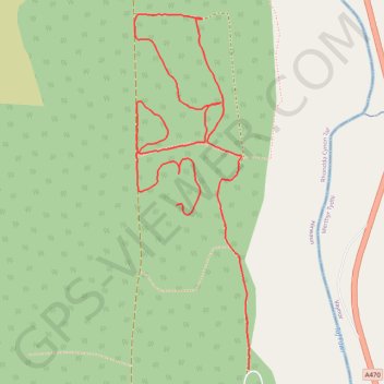
Garwnant
- Distance: 1.7 mi
- Elevation gain: 98 m
- Maximum elevation: 360 m
- Elevation loss: 66 m
- Minimum elevation: 303 m
- Moving time: 37 m 21 s
- Moving speed: 2.7 mph
- Maximum speed: 4.0 mph
- Total time: 37 m 21 s
- Global speed: 2.7 mph
Interactive trail map
Trail profile
- Distance: 1.7 mi
- Elevation gain: 98 m
- Maximum elevation: 360 m
- Elevation loss: 66 m
- Minimum elevation: 303 m
- Moving time: 37 m 21 s
- Moving speed: 2.7 mph
- Maximum speed: 4.0 mph
- Total time: 37 m 21 s
- Global speed: 2.7 mph
About this trail
Name: Garwnant trail, distance, elevation, map, profile, GPS track
Coordinates: 51.81078 -3.45239 51.81866 -3.44827
Topography: Merthyr Tydfil County Borough topographic map, elevation, terrain
Other hiking, mountain biking, running and outdoor activity trails
Click on a trail to view its statistics, map and profile.
The Headstock 500
United Kingdom > Wales > Newport > Newport
Distance: 300.4 mi • Elevation gain: 9,616 m • Maximum elevation: 691 m
Treorchy, Cearphilly, Pen y Fan
United Kingdom > Wales > Caerphilly County Borough > Tredegar
Distance: 79.1 mi • Elevation gain: 1,934 m • Maximum elevation: 501 m